Kalamazoo, Van Buren Counties under Winter Storm Warning; Calhoun under Winter Weather Advisory
The Winter Storm Watch for Kalamazoo County has now been upgraded to a warning. A few things you should know below.
According to the National Weather Service as of 6:45am Wednesday Morning,
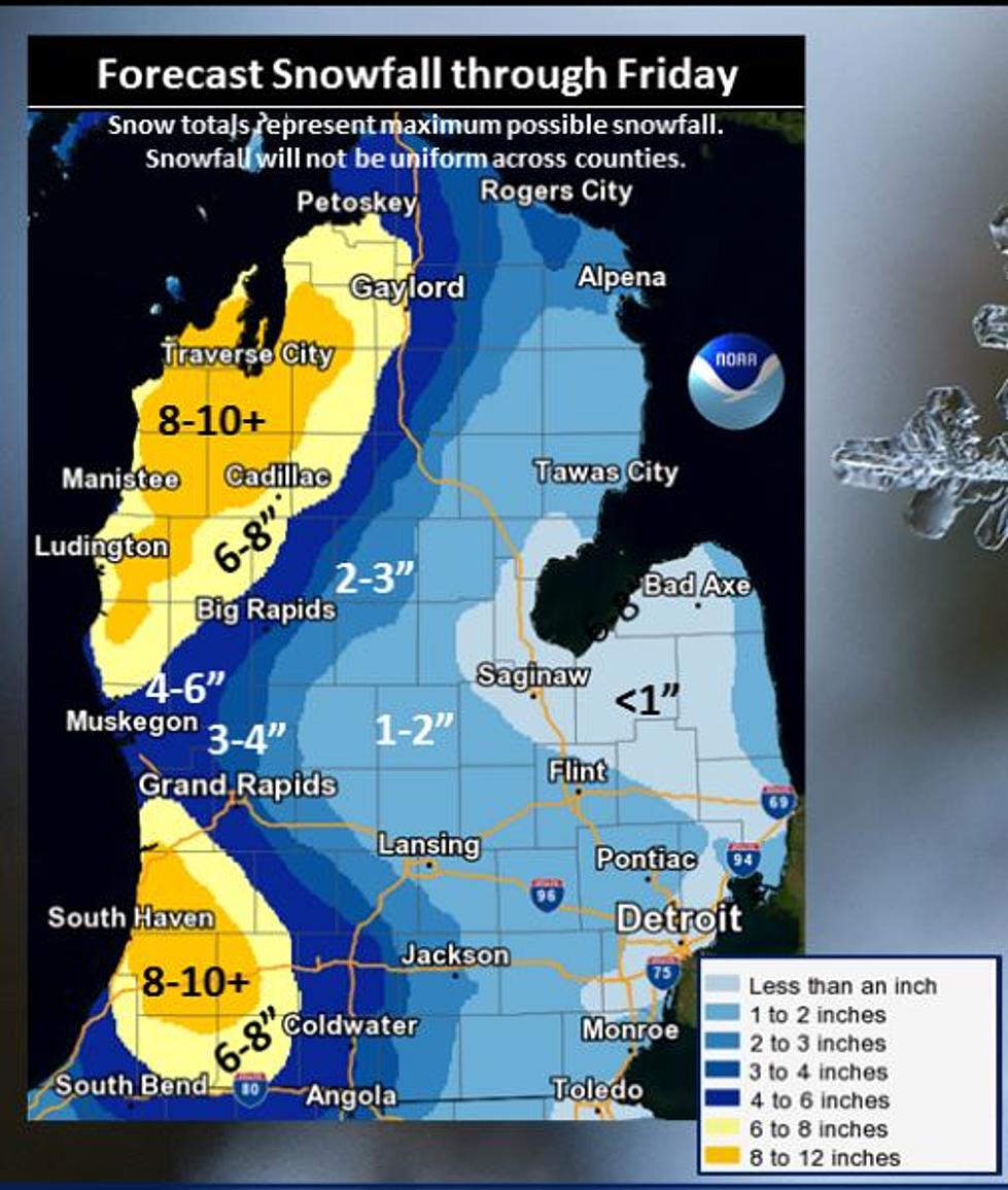
The lake effect snow machine will get cranking tonight! Snow is expected off of Lake Michigan from overnight through the day on Friday. The heaviest snow will fall from the Thursday morning commute through the Friday morning commute. The highest snowfall totals will be found up towards Ludington, Baldwin and Pentwater and in the Southwest corner of the state toward Allegan, South Haven and Paw Paw. Remember due to the very nature of lake effect snow, totals will vary widely across counties and the snow will not be uniform. Heavy bands of snow are possible with near whiteout conditions. Gusty west to northwest winds will create areas of blowing and drifting snow. If travelling in Western Lower Michigan the next couple days be prepared to slow down and allow extra travel time, as roads will become snow covered and slippery with temperatures in the 20s. It will be mostly cloudy today, the calm before the storm, with a few light snow showers.
The Winter Storm Warning for Kalamazoo, Van Buren and Allegan Counties will be in effect from Midnight tonight (Wednesday Night) til 4 PM Friday Afternoon.
Winter Storm Advisory is in effect for Calhoun and Barry Counties with 3 to 6 inches of snowfall anticipated.
If you've ever thought the snow is far heavier on I-94 West of US 131. There seems to be an imaginary line there that mother nature follows when she drops her Lake Effect snow on us.
We are expecting gusting winds and moments of white out conditions. Please take your time getting where you need to go during this storm. It could be rough out their for the rest of the week.
More From 107.7 WRKR-FM